The Roof of the World is Falling: Inside the Devastating 2026 Nepal-China Border Flood
The Himalayas have always been a place of awe, majesty, and profound silence. But on the morning of August 26, 2026, that silence was violently replaced by a deafening roar that brought unimaginable destruction to the Nepal-China border. What happened that day was not just a natural disaster. It was a terrifying glimpse into a fragile future, an apocalyptic wall of ice, rock, and mud that erased entire communities and took thousands of lives in a matter of minutes.
As a writer deeply invested in the relationship between our environment and human survival, I find the sheer scale of this tragedy hard to put into words. We are not talking about a slowly rising river from heavy monsoon rains. We are talking about a mountain literally falling apart. The events that unfolded along the Trishuli River serve as a brutal wake-up call. The impacts of global warming are no longer a distant threat for future generations. They are happening right now, and the roof of our world is crumbling down into the valleys below.
The Origin: How a Mountain Collapsed
To truly grasp the magnitude of this catastrophe, we have to look at how and where it all started. The epicenter of the disaster was the towering north face of Langtang Lirung, a majestic peak overlooking the border between Nepal and the Tibet Autonomous Region of China.
At approximately 8:37 AM local time, seismometers around the globe picked up a magnitude 5.2 tremor. Initially, many assumed this was a tectonic earthquake that triggered a landslide. However, scientists, geomorphologists, and the United States Geological Survey later confirmed a much more terrifying reality: the seismic signal was not the cause, but rather the result of the collapse itself.
A massive hanging glacier, situated at an altitude of around 5,000 meters, suffered a catastrophic bedrock failure. A clean cleavage about 1.5 kilometers wide detached from the mountain, sending up to 200 million cubic meters of ice and rock plummeting vertically for over 1,000 meters.
When a mass of that immense size freefalls, the kinetic energy is unfathomable. The friction and velocity generated by the impact instantly melted vast quantities of the glacier's ice. This sudden explosion of meltwater mixed with pulverized rock and soil to create a high-energy, hyper-concentrated debris flow. This was not a traditional Glacial Lake Outburst Flood where water slowly overtops a natural dam. This was a spontaneous, explosive rock and ice avalanche that surged into the Lhende Khola tributary and then violently into the main artery of the Trishuli River, known upstream as the Bhotekoshi.
Minutes to Destruction: The Failure of Early Warnings
The most chilling aspect of the August 26 disaster was its unprecedented speed. Down in the valleys, there was no rain reported that morning, and residents had no reason to suspect that death was hurtling toward them from above.
Just seven minutes after the initial mountain collapse, a surveillance camera at the Gyirong Port, a critical border crossing between China and Nepal, captured a black wall of water and debris completely obliterating the multi-story customs building. The people at the checkpoint had absolutely no time to seek higher ground. The sheer force of the flood swept away everything in its path.
One of the most agonizing questions is why the early warning systems failed so completely. After a smaller glacial lake flood damaged the border point in July 2025, Chinese authorities had actually upgraded their defenses in Gyirong County. They built flood walls, updated emergency plans, and installed sentry systems to monitor water levels.
Tragically, these systems were completely outmatched. They were designed and optimized to detect the gradual rise of water levels typical of monsoon rains or slowly expanding glacial lakes. They were never calibrated for an instant, explosive displacement of a collapsing mountain. The flood moved with such violent velocity that upstream monitoring stations in Nepal were physically ripped from their foundations before they could even transmit an alert. The disaster exposed a fatal flaw in how we prepare for mountain hazards. We are fighting the climate threats of tomorrow with the tools of yesterday.
The Heartbreaking Human Toll
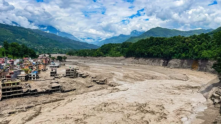
As the torrent cascaded downstream, it tore through a 72-kilometer stretch of the Trishuli River valley. The floodwaters heavily impacted the Nepali districts of Rasuwa, Nuwakot, Dhading, Gorkha, and Bagmati Province. Settlements that had stood for generations were instantly swallowed by churning mud.
The human cost is staggering. As of early September 2026, the confirmed death toll in Nepal alone has surpassed 1,398 people, with over 6,672 severely injured. Even more devastating is the number of the missing, which stands at an unfathomable 5,555 individuals in Nepal. Across the border in the Tibet Autonomous Region of China, at least 43 people have died and 519 more remain unaccounted for.
The sheer power of the flood was so immense that the bodies of some victims were carried up to 240 kilometers downstream, crossing international borders into neighboring India. Families are left in a state of unimaginable grief, wandering scarred riverbanks, and desperately waiting for news.
Rescue operations have been heroic but incredibly difficult. In Rasuwa alone, security personnel and local residents managed to rescue over 1,313 individuals alive, including 86 foreign tourists who were airlifted to safety from stranded areas like Gosainkund via helicopters. The Nepali government and Armed Police Force also coordinated the repatriation of 576 citizens who were left stranded on the Chinese side of the border after roads and bridges were washed away. Despite these immense efforts, the landscape of grief remains vast. Among the missing are dozens of police officers, army personnel, armed police, and government employees who were stationed in the region when the wave hit.
Secondary Hazards and Information Control
The disaster did not end on the morning of August 26. In the days following the initial collapse, Chinese high-altitude drones deployed from Xigatse overflying the avalanche site confirmed a terrifying new development. The falling debris had impounded the Lhende Khola river, creating a precarious natural barrier lake. This massive accumulation of loose sediment and trapped water meant that any secondary outburst could unleash another wave of devastation, keeping downstream residents in a state of constant terror and severely complicating recovery missions.
Adding to the complexity of the disaster was the stark difference in how information was handled across the border. While raw footage of the devastation circulated freely in Nepal, a digital crackdown quickly followed on the Chinese side. Censors rapidly erased viral footage of the destroyed Gyirong Port border gate and redirected trending social media topics toward official state rescue narratives. This strict information control erased crucial public inquiry regarding the vulnerability of the state-of-the-art border facility, which had already suffered from mudslides during the flood seasons of 2024 and 2025. Erasing these discussions blocked necessary conversations about site selection, infrastructure resilience, and the complete failure of early-warning systems in Tibet.
Economic Devastation and the Hydropower Crisis
Beyond the irreplaceable loss of human life, the economic devastation is absolute. The flood acted as a massive eraser, wiping away decades of infrastructure and development. Preliminary estimates place the property damage in Nepal at over 387 billion Nepalese Rupees, which equates to roughly 2.57 billion US Dollars.
The Gyirong Port crossing, a vital overland trade hub that accounted for 30 percent of all commerce between Nepal and China, was destroyed. The crossing had seen more than 100,000 people travel through it in just the first half of 2026 before being reduced to ruins.
Perhaps the most significant long-term economic blow has been dealt to Nepal's energy sector. Nepal has long held a policy of harnessing its fast-flowing rivers for hydroelectricity, aiming to export power and fuel its own economic growth. The August 26 flood severely jeopardized this strategy, knocking out around 10 percent of the country's installed power from the national grid.
The rushing mud and boulders wiped out or severely damaged 281 megawatts of installed capacity and ruined another 388 megawatts of projects that were under construction. Furthermore, with transmission lines along the Trishuli riverbank washed away, another 150 megawatts of power were completely cut off from the grid. This disaster has ignited a fierce debate about the future of Nepal's clean energy targets. Building massive dams and power plants in narrow, geologically fragile, and snow-fed river valleys is proving to be a highly dangerous gamble as global temperatures continue to rise.
The Invisible Culprit: Global Warming
We cannot discuss this tragedy without confronting the uncomfortable truth driving it. While the Himalayas are naturally active and prone to landslides, scientists and glaciologists point to a direct link between this specific disaster and global warming.
The Himalayas are heating up twice as fast as the global average. For thousands of years, the high-altitude regions have been held together by permafrost, the permanently frozen ground that acts as a structural glue for rocks, soil, and ice. But as global temperatures soar, this permafrost is thawing at an unprecedented rate.
When the ice that cements the mountainsides melts, the bedrock fractures and loosens. Water seeps into pre-existing cracks, destabilizing the massive ice caps suspended above the valleys. The glaciers are not just shrinking backwards; they are literally rotting from the inside out. Analysis of satellite imagery found that the glacier north of Langtang Lirung had been moving around 10 millimeters per month early in 2026, but the rate dangerously accelerated in the weeks just prior to the collapse. The disaster on Langtang Lirung is a clear symptom of a cryosphere in crisis. It proves that climate change is creating new, highly destructive threats that we have never fully prepared for.
A Warning for the Future: What Must Change
The catastrophic 2026 Nepal-China border flood must serve as a global turning point. We can no longer look at mountain infrastructure and disaster preparedness through the lens of the past. Several radical changes must happen if we are to prevent further mass casualties.
First, there needs to be a fundamental reassessment of infrastructure development in the Himalayas. The rush to build hydropower dams in narrow, glaciated catchments needs to be paused and reevaluated. We need comprehensive hazard zonations that account for worst-case scenarios like sudden rock and ice avalanches, not just standard seasonal floods.
Second, our early warning systems must be entirely reimagined. We need advanced technology capable of instantly detecting seismic signals from rockfalls and ice collapses high up in the mountains. These sensors must be linked to automated communication networks that can immediately trigger alarms in downstream communities, giving people precious minutes to reach higher ground before the water arrives.
Finally, nature does not respect international borders, and our disaster management should not either. There must be deeper, transparent cooperation between Nepal, China, and India. Real-time sharing of hydrological data, joint satellite monitoring of high-altitude glaciers, and coordinated cross-border rescue protocols are absolute necessities for the safety of millions living downstream.
The tragedy that struck the Trishuli and Lhende Khola river valleys in late August 2026 will forever scar the Himalayas. The thousands of lives lost and the families forever broken are the frontline victims of an earth pushed dangerously out of balance. As the painful process of recovery continues, the international community must listen to the roar of the crumbling mountains. The disaster of August 2026 is not a historical anomaly. Unless we adapt our strategies and aggressively curb the global warming that is melting our peaks, this tragedy is a grim preview of what is yet to come.

Prabin Uprety
Founder, SecureX Lab • Full-stack developer and cybersecurity researcher based in Birtamode, Nepal
Prabin Uprety is the founder of SecureX Lab, a software development and SaaS company based in Birtamode-4, Jhapa, Nepal. With over 5 years of experience in full-stack development (React, Next.js, Django, Node.js), Prabin specializes in building privacy-first tools for Nepali users and contributing to the local open-source community. His work focuses on bridging the gap between advanced technology and practical, everyday needs — from secure document conversion to Bikram Sambat date utilities. Prabin holds a degree in Computer Science and regularly writes about cybersecurity, AI, and Nepal's digital transformation. Connect with him on LinkedIn or follow his work at securexlab.com.